Not a bit of it!
So we set off on another New Year’s Day – and what a grey, miserable start to 2011 it was as well. The port was covered in a low cloud that seemed to just heap further misery on what is, at first site, one of the country’s poorest towns. Its fine buildings are testament to Dover’s great seafaring past – but they sit uncomfortably close with run down, derelict and boarded up neighbours. I always feel really sorry to see the state of these once great towns particularly the coastal towns – Dover and Hastings in the south, Skegness and Cleethorpes in the east and Bridlington in the north. I don’t pity them – I do feel genuine sorrow at their plight. Who do you point the finger at? Well, Dover certainly shouldn’t be on its knees – it’s the country’s best known and busiest port; its counterparts in France, Calais, Boulogne and the villages in between, have made huge efforts to build new infrastructure and to attract visitors to do more than just pass through. Dover seems to have done nothing and its crumbling town centre is an indictment on those who have been entrusted with its custody.


Anyway, rant over. Certainly the weather matched our surroundings as we set off through the town centre towards the magnificent Dover Castle overlooking the equally magnificent chalk cliffs.
Dover’s strategic position has always been evident throughout its history and research and archaeological findings suggest that it has been a prime gateway to what is now continental Europe. Did you know? Dover is one of only a few places in Britain – London, Cornwall and Canterbury being other examples – to have a corresponding name in the French language, Douvres. One for down the pub!
Dover’s name originated from its river – the River Dour; and the cliffs also gave Britain its ancient name of Albion ("white"). The Romans called it Porte Dubris – a fortified fort - and its modern name was in use at least by the time Shakespeare wrote 'King Lear', in which the town and its cliffs play a prominent role. Indeed, forts were built above the port and lighthouses constructed to guide ships - one of the best-preserved Roman villas in Britain is in Dover, but after two attempts to find it we gave up!
Dover has also figured largely in the defence of the country - notably the French during the Napoleonic Wars and the Germans during World War II. It is natural that Dover should be seen as an ideal place to come across for a pop at us Brits because the Channel here is at its narrowest point in the Straits of Dover. It is also the busiest shipping lane in the world.
One of the more pleasant parts of the town is the promenade where we started our walk today. Here there are landmarks celebrating some of the port’s great achievements.
We stopped by the Dunkirk memorial and looking around the sea front it was difficult to comprehend the enormity of that operation. The Dunkirk evacuation carried the codename Operation Dynamo – named after the Dynamo room located below Dover Castle in the naval headquarters. It was in this room that the British planned the operation.

The operation took place in June 1940, when British, French and Belgian troops were cut off by the German army during the Battle of Dunkirk. Some 340,000 people were evacuated by a flotilla of boats of all shapes and sizes. Whilst Dunkirk has gone down in history as some kind of magnificent achievement for British grit and enterprise what is often forgotten is that at the time Churchill called the event a "a colossal military disaster", saying that "the whole root and core and brain of the British Army" had been stranded at Dunkirk and seemed about to perish or be captured.
A little further on and there’s more evidence of Dover’s role in the 2nd World War with a plaque made from armour plating dismantled from one of the huge guns located at Sangatte across the Channel and which rained bombs down on Dover. Some 2,226 of
these monster shells fell in, on or around the port.

Further still along the promenade and we come across the official start/finish line for cross channel swimmers. I hadn’t realized that swimming the channel wasn’t just … well, swimming across the channel. But no – it actually exists as an officially recognised sport. The sport of Channel Swimming goes back to the latter part of the 19th century when Captain Matthew Webb – him from the front of matchboxes - made the first channel swim.


And if you fancy having a go at swimming the channel – you can’t just strip to your cossie on the beach and wade in. You have to register and book your swim with the Channel Swimming Association – a process that has to be undertaken at not insignificant cost. One of the requirements is to book a pilot to accompany you and these sometimes need to be booked a couple of years in advance.
Don’t think I’ll bother then.
As we (eventually) left the seafront and headed into town we passed the monument erected to the memory of the officers and men of the 60th Rifles who fell in the Indian Mutiny – this is adjacent to the site of the Grand Hotel which was destroyed by a bomb in 1940.

As we headed up towards the Castle we passed by some of the dilapidated buildings which so add to the town’s current reputation. As we leave them behind though the magnificence of the Castle soon transports us to a different world. We would have liked to have taken a closer look at the Castle but struggled to find any way of walking closer to it than the main road that swoops up and around the grounds.


Dover Castle is the oldest fort in England and in addition to its use throughout the centuries as a Castle, the area is also home to a number of underground tunnels used variously as garrisons for soldiers, as important communications conduits during the 2nd World War and even as a place for regional VIPs to be kept in the event of a nuclear war.


Continuing our walk we were once again diverted – this time by signs to the Louis Bleriot Memorial. The memorial to the first person to fly the English Channel in an aeroplane is in the form of a stone silhouette of Bleriot’s plane set into the ground at the place where he landed in July 1909, winning a prize of £1,000 from the Daily Mail.


Bleriot, a motorcar headlamp manufacturer, had injured his foot and walked to his plane with the aid of crutches. He took off at 4.37am and, guided by smoke from a French destroyer, he spotted St Margaret’s Bay. Turning towards Dover he was caught by the wind and made a crash landing in Northfall Meadow, just behind the Castle, breaking the undercarriage and propeller. The whole journey had taken 20 minutes.
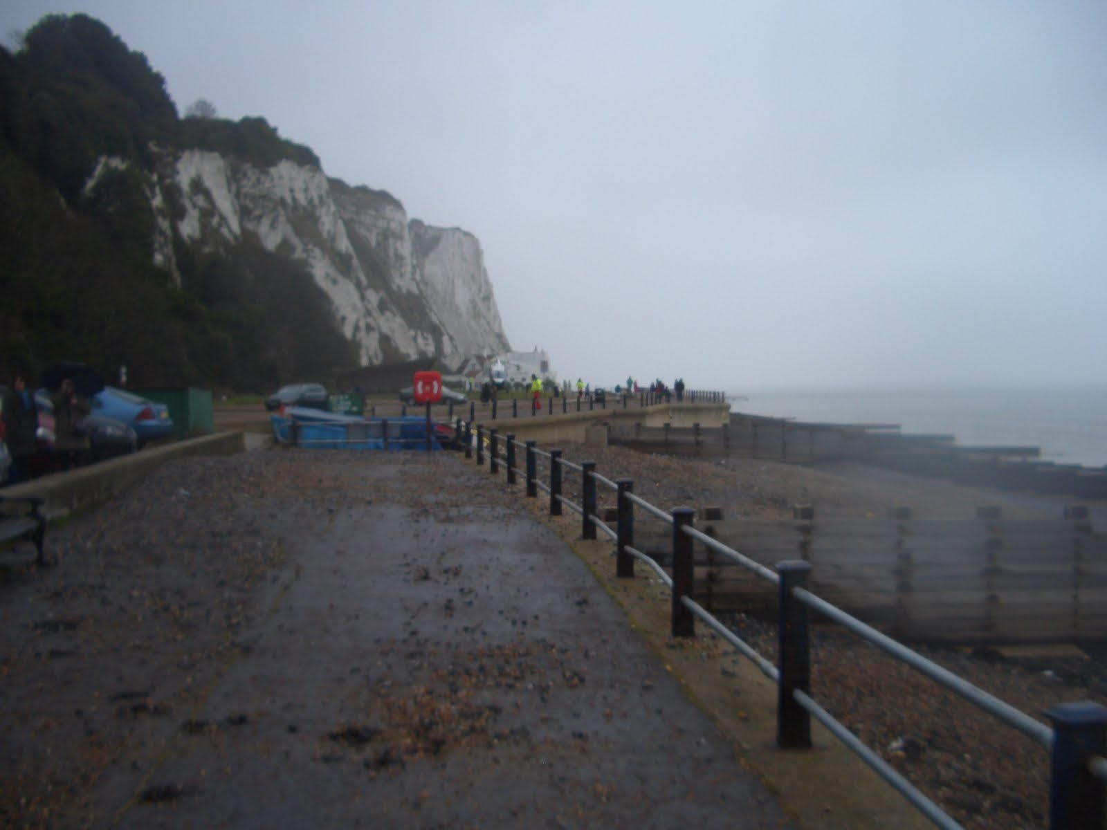
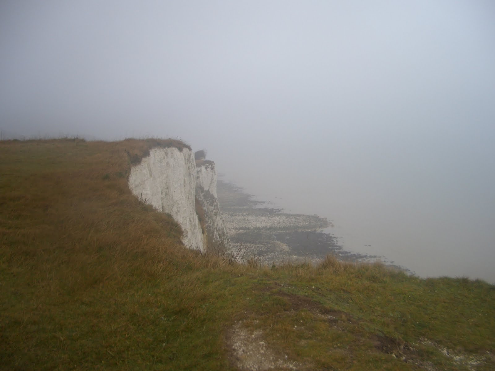
Once we began to leave the Castle behind us we reached the coastal path once again by the White Cliffs of Dover Visitor Centre. I have lived in the south east for almost thirty years and I have seen and admired the White Cliffs since I first crossed the Channel with my parents on the old Townsend Thoresen Ferry – but this was to be my first time actually setting foot on them.


This area is now almost all owned by the National Trust and we passed first along Langdon Cliffs which afford a perfect view of the Channel. Three searchlight batteries - known as the Langdon Lights - were built into the base of the cliffs below here during World War II, so that any ship trying to enter the bay could be illuminated while it was checked.
Last night’s New Year’s Eve festivities hadn’t entirely left our systems and a coffee was called for – so sitting down in the Visitors Centre it gave us an opportunity to take a look around and discover more about the area.

The cliffs are up to 300 feet high and are made up of millions of small sea creatures and coral from the bottom of an ancient tropical ocean, the chalk is porous, soft and easily worn by the action of the waves. The chalk downland on top of the cliffs is very rare, with many of the plants pre-dating the last Ice Age and some being almost unique to this part of Kent.
Just above the Visitor Centre are a number of long, low buildings – which are disused prison blocks. When transportation to the Colonies ended, there was a problem of how to occupy the many prisoners who would previously have been transported. It was therefore decided that it would be a good idea to build Dover Harbour using convict labour and a prison was constructed here to house the men. As it was the huts were never used for the harbour construction – instead the prisoners spent their time doing what prisoners are supposed to do. Sewing mailbags.

Subsequently the buildings were used by the Army as a Military Prison and, indeed, became the largest military prison in the country until its closure in 1908. Its final function was as a POW camp for German soldiers awaiting repatriation and the site was closed for good in 1948.
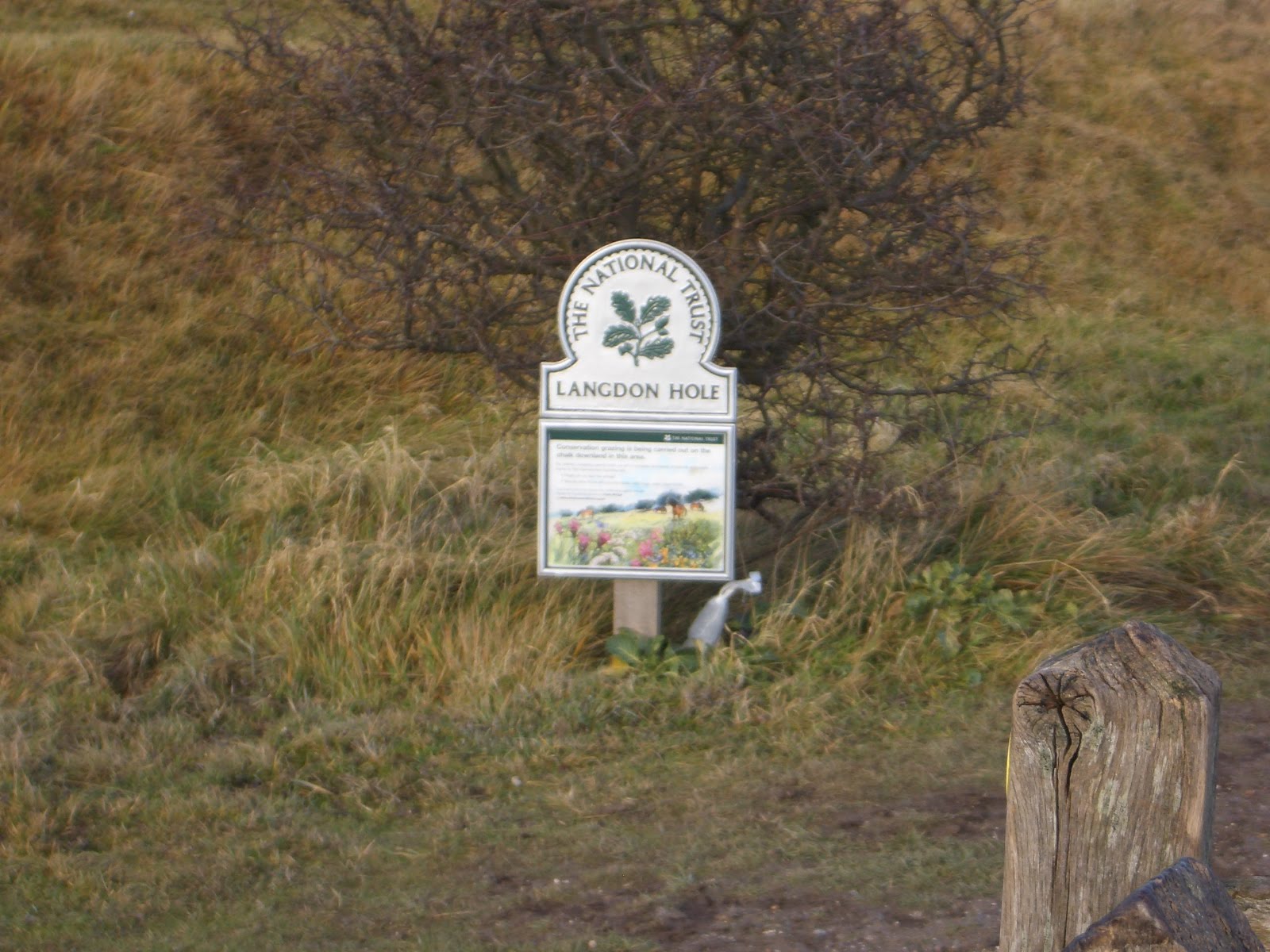
We continued along the top of the cliffs on the coastal footpath which, on a decent day, would offer magnificent views. Today, though, was very murky – but that didn’t stop the locals turning out en masse – the path was very, very busy. We came across Langdon Hole – the site of one of tunnels built beneath the Castle. This particular tunnel is often referred to as 'DUMPY B'.


Eventually we came across another of the area’s iconic features – the South Foreland Lighthouse. The Lighthouse was built in Victorian times and was used to warn ships approaching the nearby Goodwin Sands. It went out of service in 1988 and is currently owned by the National Trust. You may not know this, but … South Foreland was the first lighthouse to use an electric light. There. Feel enlightened?


The Lighthouse was used by Guglielmo Marconi during his work on radio waves, receiving the first ship-to-shore message from the East Goodwin lightship, the first ship-to-shore distress message (when a steamship ran into the same lightship, and the lighthouse relayed the message up the coast to the Walmer lifeboat), and the first international transmission (from Wimereux, France, in 1899).
Originally there was another lighthouse further down towards the cliff edge to give a bearing on the leading lights principle when a ship was at the point where it could safely turn left into the Downs behind the sands or right to go safely around the Sands. They were both built in the 1840s. However, the Sands shifted over the following years until this bearing became dangerously inaccurate and so the lower light was taken out of service in 1910. It still survives as part of a private garden but is under threat from cliff erosion.
Out to sea from this spot are the notorious Goodwin Sands - a 10-mile-long sand bank in the English Channel. As the sands lie close to major shipping channels, more than 2,000 ships are believed to have been wrecked upon it, including the Radio Caroline vessel MV Ross Revenge, which drifted onto the Sands in November 1991, effectively ending the era of offshore pirate radio in Britain.
The weather by now had deteriorated and we were walking in a constant drizzle by the time we reached the outskirts of St Margaret’s Bay. The local horses provided some light entertainment on the cliff top path as we approached the village. At the entrance to the village is a small museum with artefacts illustrating the wartime past of the community – plus an exhibition on former resident Noel Coward, who lived in a beach cottage here – quite close to Ian Fleming. In the nearby Pines Gardens was a plaque commemorating the fact that Julius Caesar had landed nearby in Walmer – and there was not to be another invasion of our lands until 1066 .. and there has been none since.
So there.


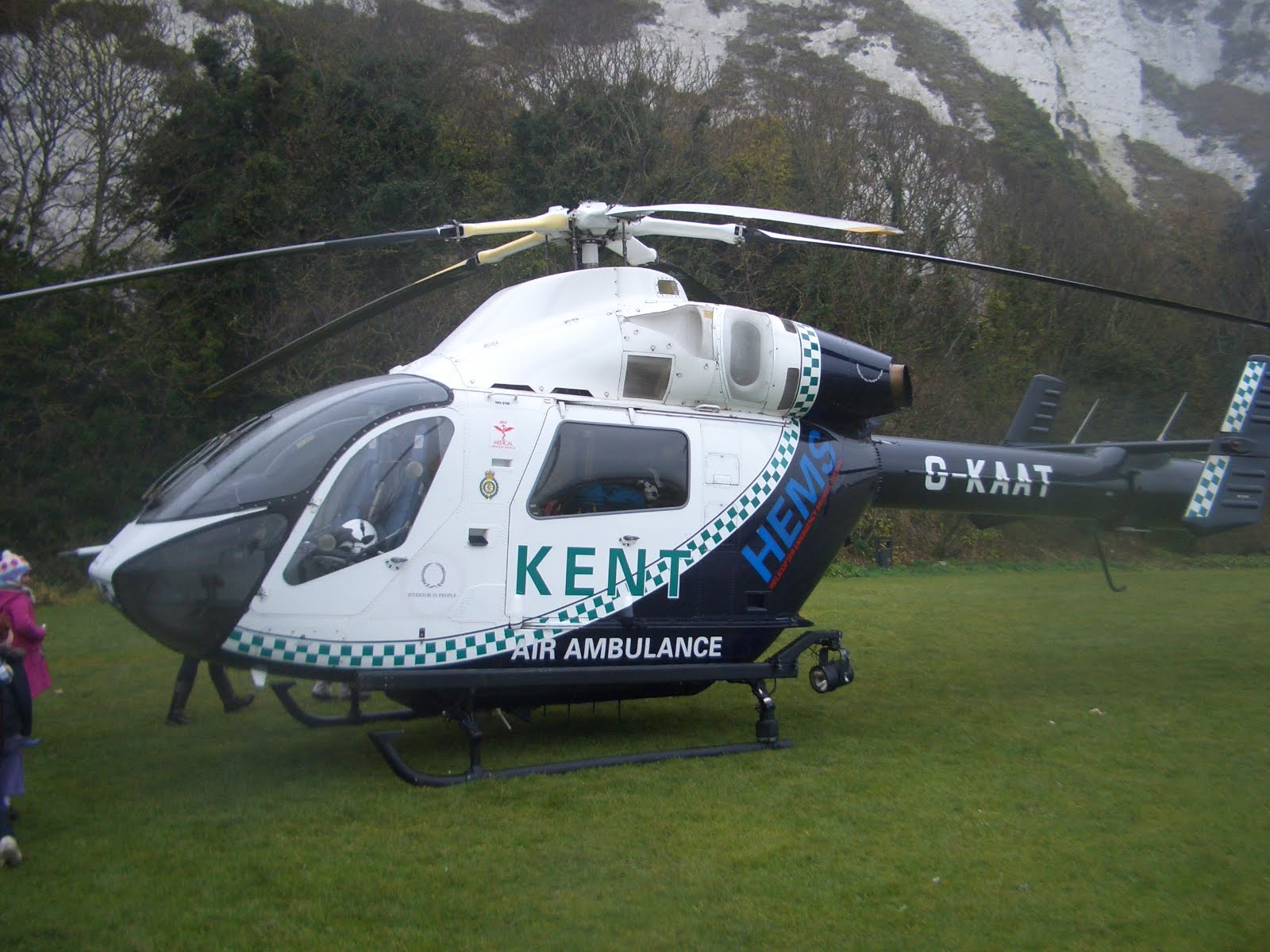
As we started to descend to the bay below us the air was suddenly filled with sirens and we counted around a dozen different blue flashing lights illuminating the murky skies ahead of us – and when we finally got down to sea level we were greeted with just about every conceivable type of emergency vehicle – coastguards, police, ambulance, fire engine – even the air ambulance! There had been a cliff fall and the authorities had feared there could be day trippers trapped underneath the debris. Despite the incident featuring on the BBC News – a fact that alerted friends of ours who knew we would be close by – no causalities were reported, but it did brighten up the afternoon.http://www.bbc.co.uk/news/uk-england-kent-12103301


Climbing once more out of St Margaret’s to rejoin the coastal path high up on the cliff, the weather showed no sign of clearing and it was becoming a bit of a wet drudge kind of walk. The light was failing too – despite it still being early afternoon. We decided to carry on to Kingsdown and we made our way initially to the memorial to The Dover Patrol which dominates the local skyline. The Dover Patrol was a secretive and very important navy unit in the First World War whose job it was to prevent enemy German shipping - primarily submarines — from accessing the Channel from the Atlantic Ocean.


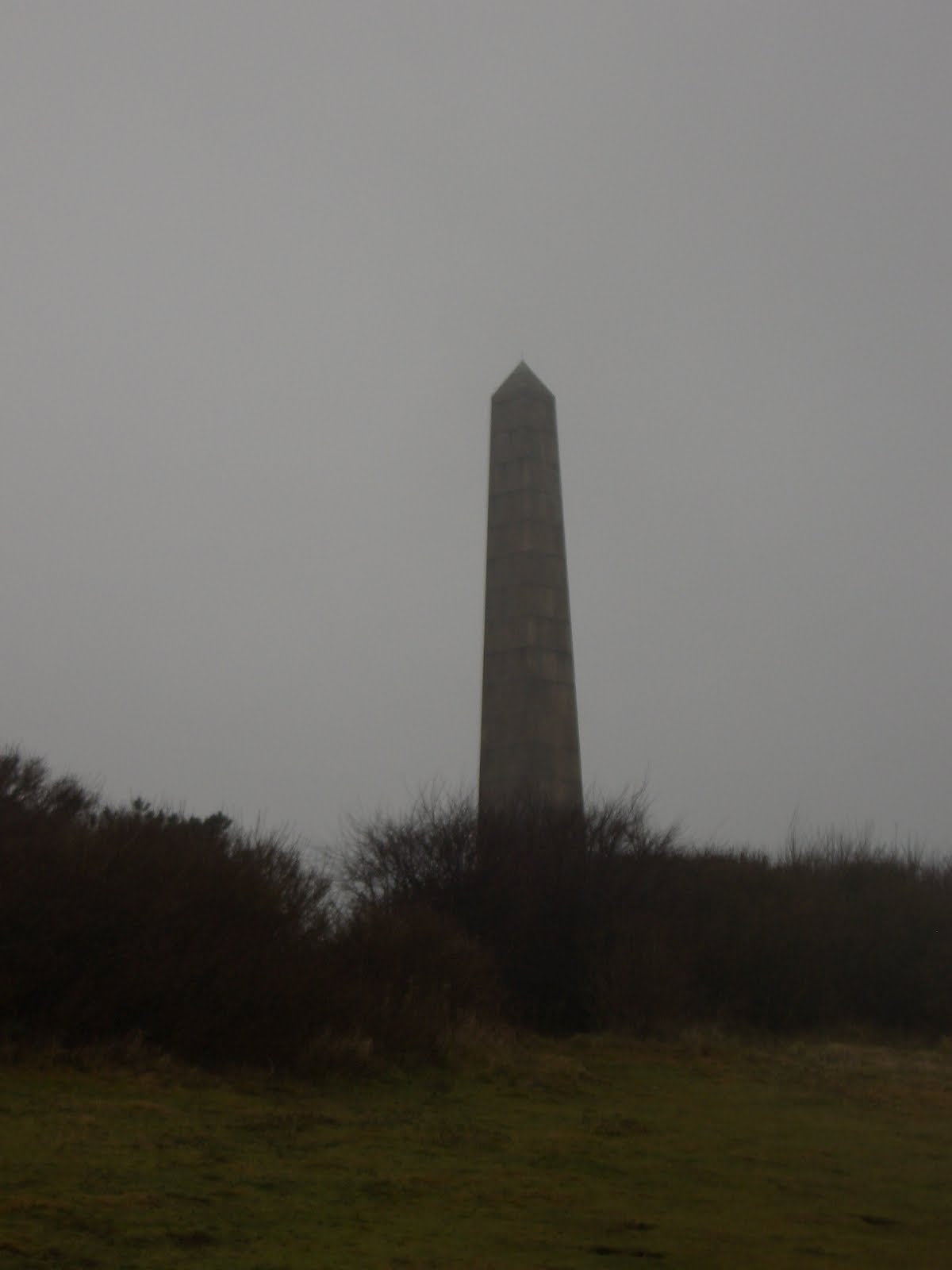


After the war, a fund was set up to erect a memorial to the Dover Patrol and in 1921, the memorial here at Leathercote Point near St Margaret’s Bay was unveiled. Similar memorials stand at Cap Blanc Nez on the French Coast and overlooking New York harbour.
We began our descent yet again to sea level and soon arrived at our destination for the day’s walk – Kingsdown – where, pretty damp by now, we settled in the warmth of the Zetland Arms for a beer and a bowl of chips before getting the taxi back to Dover.


Miles covered 8.74 miles
Time taken 3 hours and 44 minutes
Miles covered to date 48.34 miles
Time taken to date 16 hours and 27 minutes