The Plan ....

It is impossible to undertake a task of this magnitude without some kind of plan. However, this journey is not intended to take on the fine men and women of the long distance walking world. We would like to try and complete the journey - but if we do so, we will enjoy every minute of it. If it starts to become an obsession or ceases to be enjoyable then I suspect we'll simply stop.

Whilst it will no doubt be a physical endurance it is not going to be a chore. We want to walk around this marvelous country because we want to enjoy its sights, its sounds and its smells.

And that is all.

However, we do acknowledge that there has to be some kind of plan - so, this is what we will be looking to do:

1. We will start and (hopefully) finish in Rye, East Sussex.
2. We will travel in an anti-clockwise direction
3. We will walk along the coastline of mainland Britain, but will also incorporate any island that is connected to the mainland by a bridge. So, we would hope to include Anglesey but not the Isle of Wight.
4. Estuaries will be crossed by bridge or by ferry - and we'll decide which is most appropriate.
5. We have no time limit for completing or ending the journey.

Saturday 22 May 2010

Walk 5 Capel-le-Ferne to Dover 22nd May 2010

We began the next stage of our walk by returning to Capel-le-Ferne, the site of the end of our last somewhat aborted attempt to walk from Folkestone to Dover. It doesn't seem like five minutes since we started this journey in Rye in snow and ice and here we were preparing to set off on a glorious day having left home basking with temperatures in the mid 20s. By the coast it was a little cooler with a fair breeze – but it was still a fine day for a walk.


Of course we were now on high above the channel on the cliff top. We set off from the village of Capel-le-Ferne, whose name means “Chapel in the Ferns". Perched on top of the White Cliffs of Dover, the village has a surprisingly large population of some 2,400 – I’ve no idea where they put them all because it was exceptionally quiet on this particular Saturday afternoon. The village’s main claim to fame, apart from having a very French-sounding name, is that it is home to the Battle of Britain museum – and, of course, the Channel Tunnel runs underneath the northernmost part of the village.
We set off on the North Downs Way which twins with the Saxon Shore Way from here to Dover. The Saxon Shore Way is a long-distance footpath which starts at Gravesend and traces the south east of England coastline as it was in Roman times. This doesn't follow today’s actual coastline due to the fact that in those far-off times, Romney Marsh was virtually a beach! The path runs all the way to Hastings, covering some 163 miles in total.

The start of our journey today took us along Abbott's Cliff – and the edge of the cliff was certainly not for the faint hearted! There is a stunning view over the channel – but an unnerving glance towards your feet is guaranteed to get the old vertigo up and running!

Some people, however, have a different approach to such height hazards – as the handwritten sign pointed out! A little digging when we got back turned this little gem from The Daily Mail:
Death from the path

A man fell to his death after he posed for a photograph holding on to a cliff edge by a tuft of grass, coastguards said yesterday.

The 39-year-old Polish man tumbled 300ft down the sheer cliff face, landing in the bushes below at Seaton, Devon, on Sunday.

A coastguard helicopter and team were called to rescue him but paramedics declared him dead at the scene.

His death follows that of another man, thought to be Russian, who fell from a cliff top as he walked with friends at Capel-le-Ferne near Folkestone, Kent, on the same day.

Dover Coastguard said the cliff where the Russian man fell was a sheer drop of around 300ft, in an area that is popular with walkers.


So, there you have it. Beware of cliff edges – particularly if you’re from Eastern Europe. And if you’re Polish – don’t be a prat!

Our walk along the cliff top was interspersed with .... well just bits of pointless stuff. Silly stuff. Call me a cynic if you like but a walk is really easy. You put some clothes on and some shoes – and you walk! You can have a look around at some magnificent scenery and – sure - it’s good to see little bits of eccentricity along the route. But, for goodness sake we kept bumping into stuff which was obviously paid for by some crackpot arty farty grant scheme i.e. us.


So, we came to Chalk Lines along the Chalk & Channel Way. Now the Chalk & Channel Way is OK - it’s a walking and cycling trail between Dover and Folkestone, along the National Cycle Route No 2. But they couldn't leave it at that. Oh no the walk wasn’t good enough on its own – it needed something else. So a series of art works have been installed along the route. Bits of stone stuff with engraved notes about the local flora. Not to be content with that we then came across a series of marker posts encouraging us to call a number and hear a poem especially written about the view before us. How much did this little lot cost, for God’s sake?

Give me strength.


Further along Abbots Cliff we came to Lydden Spout and the location of another of the sound mirrors, some of which we had seen near Dungeness. They were designed to detect oncoming enemy aircraft by means of acoustic amplification of the propellers’ drone - Britain built a series of these concrete sound mirrors between 1915 and 1935.


At this point the footpath links up with a cycle path which is part of the National Cycle Network - route no. 2 if you are interested. The National Cycle Network was created by a bunch of beardie sandal-wearers who must have dome something right because they got a whopping £42 million National Lottery grant to build a load of cycle paths around our country. National Route 2 of the National Cycle Network is a long distance cycle route which will link Dover with St. Austell in Cornwall. Except the route is only fully open and signed between Dover and Brighton.

The rather fancy signs were funded by the Royal Bank of Scotland – which presumably means that we own them now.
The ground we are now walking on today is above the site of a number of old Channel Tunnel workings. The first time a tunnel under the sea to link France with England was mooted was in 1802 when a French mining engineer called Albert Mathieu put forward a proposal to tunnel under the English Channel, with illumination from oil lamps, horse-drawn coaches, and an artificial island mid-Channel for changing horses. Sounds marginally better than we what we have now.

In the 1830s and again in 1856 ideas were presented for tunnels – indeed a proposal was presented to Napoleon III for a railway tunnel between Cap Gris Nez to England at a cost of 170 million francs - less than £7 million.

In 1881, the Anglo-French Submarine Railway Company dug a 7 ft diameter, 6,211 ft pilot tunnel from Shakespeare Cliff but the project was abandoned on the grounds that a tunnel would compromise Britain's national defences.

Eventually both the British and French governments supported the concept of a tunnel inking the two countries and in 1974 another attempt was made. A tunnel was cut through the cliff to reach the old colliery site and the boring machine put in place, only for the new Labour government to cancel it in 1975. Eventually of course the project did get off the ground though God knows how much money it has cost and lost since then.

As the Tunnel Boring Machines cut the chalk marl it was loaded onto rail tipper wagons, brought back along the tunnel and then moved onto the surface by conveyor belt. Large JCBs then moved the spoil into artificial lagoons constructed with sheet piled walls - and this became what is known today as Samphire Hoe.


During the construction of the Channel Tunnel, the area was known as the Shakespeare Cliff Lower Construction Platform. In 1994 a competition was organised by Eurotunnel and the Dover Express to find a new name for the newest part of England. Hundreds of entries were received, from which the judges chose Samphire Hoe.

As the cliff footpath passes over Samphire Hoe, we arrived at Lydden Spout Battery. Lydden Spout Battery is one of a number of coastal batteries established during WW2 along the Kent Coast. It was built in 1941 and manned by men of 520 Coastal Regiment Royal Artillery.


The Lydden Spout Battery Rifle Range is also still prominent - the guns were removed in the 1950’s and the site was used as a rifle range which can still be seen today.

Amongst the ruins we spotted what appeared to be a milestone with the words Dover Borough 1934 – and the name Croft. Another bit of digging when we returned showed up that the stone refers to one Fredrick H Morecroft who was the Mayor of Dover in 1932 and 1933 but why the stone? No idea!

Another thing to puzzle us was a very round hill thing called unsurprisingly The Round Down. It is now owned and managed by the National Trust - but we can find absolutely no information whatsoever about the thing!

We came shortly to Shakespeare Cliff which dominates the western side of Dover. Some of the action of Shakespeare’s play ‘King Lear’ takes place around Dover. On 4 October 1605 the ‘King’s Men’, Shakespeare’s theatre company, visited Dover and it is quite likely that Shakespeare himself was with them. He certainly must have visited Dover at sometime as he uses one of its landmarks as the setting for one scene.


The walk down into Dover is somewhat disappointing. It’s very, very urban, skirting the A20 dual carriageway. Despite the relative prosperity of the port of Dover, the town itself is bordering on dilapidated in many parts. The Western Docks are in a state of decay with many derelict buildings and open space.

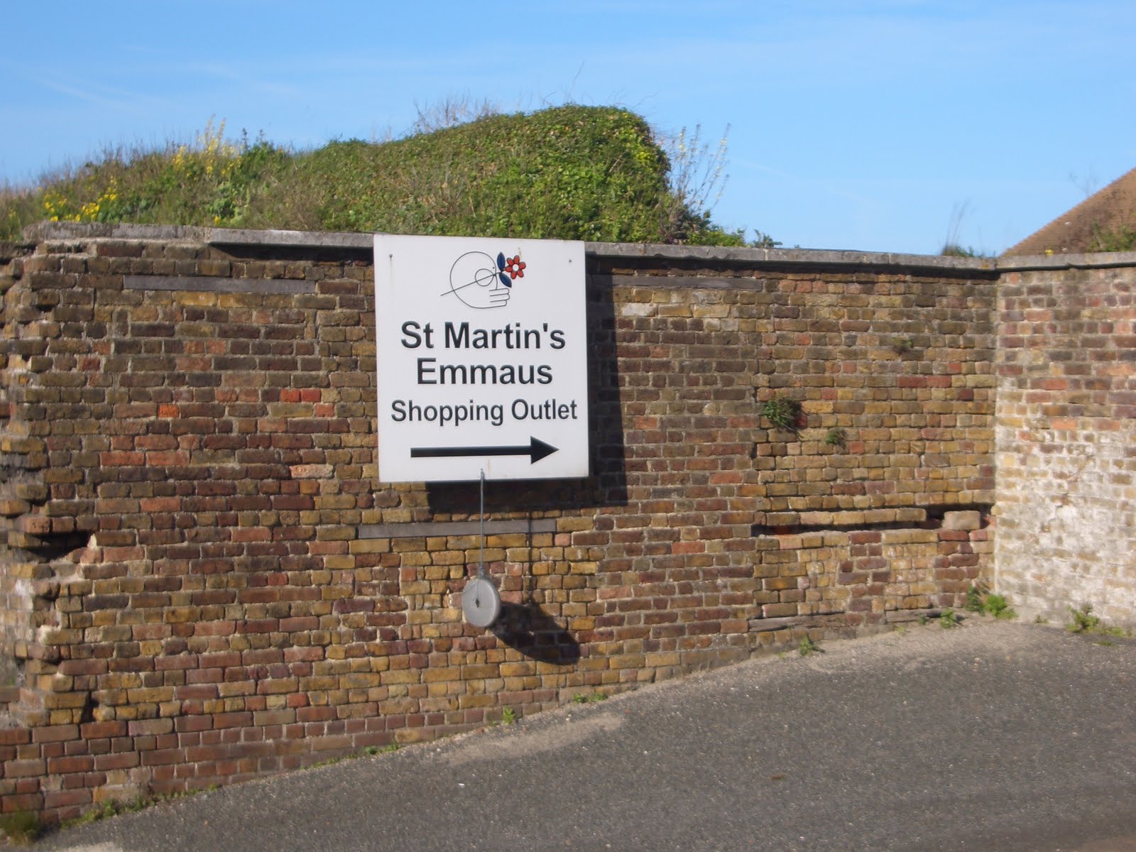
Just before we reached the western side of the port though we passed Archcliff Fort. We have driven past this place hundreds of times and never knew what was inside – so we took a peep as we walked past. And what a surprise it was too! Archcliffe Fort formed part of the coastal defences of the town from the 16th century. The first fort was constructed under Henry VIII in 1539 and 1540, although the initial fortification of the site may date back to the late 14th century. It is now the site of a community housing ex-homeless people. The community is managed by St Martin’s Emmaus and is one of over 400 communities throughout the world, of which almost 20 are in the UK, that provide a home, work and “a future” for otherwise single homeless men and women. The movement started in 1949, when the founder, AbbĂ© Pierre, started the first community in Paris. The community in Dover has been in Archcliffe Fort since 1995, when the buildings were in various states of dilapidation - its Patron is Terry Waite.


So we made our way to the conclusion of our day's walk and we entered the Port of Dover. Dover is, of course, the nearest English port to France – which is just 21 miles away - and one of Europe's largest passenger ports. The port has been owned and operated by the local Dover Harbour Board, which was formed by Royal Charter in 1606 by James I.

Dover’s history, because of its proximity to France, has always been of great strategic importance to Britain. Forts were built above the port; lighthouses were constructed to guide ships; and one of the best-preserved Roman villas in Britain is in Dover – but we didn’t see it!


And so to the end of our walk in the Marina and a decent beer and plate of nachos we had too – in Cullin’s Yard, a wine bar and bistro owned by an old friend of ours, Jim Gleeson. We know Jim from originally from his stint as Chairman of the local football club Dover Athletic – but we also bump into him from time when we’re running. Jim is a veteran of some of the most gruelling events including the notorious Marathon de Sables.

So, to use a very British phrase – the day ended in a very agreeable way. After our beer and nachos we hopped on a bus back to Capel-le-Ferne and a drive home via the local Chinese take away.

Miles covered 5.16 miles
Time taken 2 hours and 12 minutes

Miles covered to date 39.60 miles
Time taken to date 12 hours and 43 minutes

Monday 5 April 2010

Walk 4 - Folkestone to Folkestone 5th April 2010

Our walk today was notable for a number of reasons. For a start it would be the first one we had undertaken with no sign of snow – indeed so nice was the weather shorts were the order of the day! Secondly, being Easter Monday and a public holiday is there any better place to be than beside the seaside? Thirdly, however, little did we know as we set off on a jolly 8 or 9 mile walk that we would suffer our first frustration on the trip as Mother Nature conspired against us to force us to change not only our plans for the day – but virtually halved the progress we would make on today’s walk!

However, it was with a bit of a spring in our step that we set off on this Easter Monday afternoon. Our starting point was in Folkestone, of course, the finish of our previous walk from Hythe. We parked up outside the cliff railway – known as the Leas Lift. The railway/lift is closed at present although work to restore this Victorian water-powered lift is, thankfully, now getting under way. The Grade II-listed lift was built in 1885 and carried passengers for the last time in June 2009 after the local council's lease ran out. It is one of the oldest water lifts in the UK and transported people between the sea front and the promenade. Its owner, Lord Radnor, has said a company had been appointed to carry out repair work and it would reopen in June 2010.


The lift was once heaving with people making their way to the Rotunda on the sea front. The Rotunda is – or was – an iconic Folkestone landmark although one could also say that Folkestone itself was also an iconic landmark! The town once boasted a swimming pool, a boating pool, an amusement park, a ferry and a wide selection of fairground rides.

Indeed, Folkestone's beachfront was a bustling place right up to the 1960s and was still making a valiant attempt in the 1990s – and it has some place in our own family’s history being the place where a couple of our kids discovered a pathological fear of Log Flumes! It didn’t last.

Recent years have seen all the amusements swept away, with the swimming pool being filled in and the barren open space being used by the Folkestone Sunday market. To some local protest, the large Rotunda amusement park was sold off by its owner, Jimmy 'King of the Seafront Arcades' Godden in 2003 and subsequently demolished. Known as a bit of a character, he even had the bollards in the park engraved with 'JG'. Some scurrilous people have said he suffers tremendous bad luck as he has had a few things burn down - including Dreamland in Margate

The Rotunda looks a sad place these days and indeed it even features on the website www.derelictplaces.co.uk – a site documenting decaying landmarks!


Good news is in the offing though because a local bigwig – Roger de Haan – through his Folkestone Harbour Company is attempting to regenerate the harbour area, including the Rotunda.

Folkestone, of course, has a long history of cross channel traffic and the first day of August 1993 marked the 150th anniversary of the opening of the Folkestone – Boulogne route to regular sea traffic, a date fixed by the coming of the railway to the port. The line from London, via Reigate and Tonbridge, had arrived in June 1843 but as the nineteen arches of the Foord Viaduct were still under construction, a hastily built terminus was erected near the site of the present Folkestone Central station. It was not until six months later that the viaduct was completed and trains were able to use Folkestone station at its eastern end.


Folkestone Harbour wasn’t just knocked up by a bunch of local builders either, No less a person than the renowned engineer Thomas Telford built it in 1809. Although the nineteen acres of the harbour were, by the time the railway arrived, both neglected and badly silted.

Sea Containers’ purchase of the then hovercraft only operator Hoverspeed in 1987 and subsequent investment in new high speed Seacat catamarans in the early 1990s, presented Folkestone Harbour with a further lifeline, and in April 1992 a high speed Seacat Folkestone – Boulogne service was introduced. We remember using the Seacat service regularly – this was when the cross channel ferries were nothing more than cattle ships with a bar. From a business point of view, the service relied heavily on day trippers and duty free shoppers. Then, of course, the politicians had to get involved and our friends in Europe decided we were enjoying something – and consequently banned duty free shopping. With it went the bulk of the traffic and an entire industry was shut down with the inevitable consequence that, once again a question mark was raised over the future of ferry services from Folkestone to Boulogne.

The Folkestone – Boulogne service was closed in September 2000 and from then on Folkestone Harbour ceased to exist as a cross channel passenger port for the first time in its history.

There have been rumours of a service being restarted but to date nothing has happened and the town looks like what it is – a decaying seaside town desperate to bring back the good times – let’s hope the harbour regeneration scheme does what its supporters promise.


Notice the sign in the photo above?

Have you ever been out somewhere and seen something and thought – “I wonder what that is?”? I have often thought it would be a great idea to have a book called “What that is” or something similar – just to answer these questions that need to be answered – and when there’s not a chap around to ask. I suppose though we do have the internet. Anyway, we were walking along the sea front and there was a simple sign – a National Grid sign – that said “Bakers Gap”. I’d never heard of it. And the sign was on a simple non descript small building – nothing fancy or imposing. Well it turns out there’s a bit of a story behind this simple sign.

Because behind the sign was a very important part of our country’s energy resources. It is the site of the ‘Interconnector’ Oh yes it is. What’s an Interconnector? Well its only the bit of kit that joins our National Grid with that of our chums in France – so when we need a bit of their electricity or they need a bit of ours – this is where it comes from. From here the interconnector is cabled underground to Sellindge and connected to the UK transmission system. The interconnector is approximately 70km in length with 45km of underwater cable. So there you go.


Folkestone is the site of the last three Martello Towers. Situated on the East Cliff, they were built between 1804-9 to help defend Folkestone against the threatened invasion by Napoleon. Two of the towers are clearly visible, with one tucked away amongst some houses. Nearby apparently is the site of a Roman Villa that once stood here and apparently you can sometimes see the outline of the villa in the grass on a dry summer’s day. Suffice to say we saw nowt!

We continued to walk up the grass bank following a footpath that would take us up towards the cliff. We passed the Sandbanks restaurant and from here there are some pretty stunning views eastwards towards Dover.


The coastline between Folkestone and Dover is, of course, dominated by a stretch of white chalk cliffs. Apparently the series of cliff sections represents the most important single locality for studying these kind of rocks in England. Certainly the area is notorious for its preserved fossils and we saw quite a few people hunting and digging for them. Some of the people we saw even looked like fossils themselves.

We decided to head down towards the shore rather than follow the cliff top footpath which is actually part of the North Downs way – well it made sense didn’t it?

The area is known as Folkestone Warren and actually consists of a series of landslides crossed by the main Folkestone-Dover railway line. Because of the railway and the areas tendency for landslips it has meant that the area is probably the most studied bit of ground in the country. How about that?


The site has suffered twelve major landslips since 1765, and is now protected by a complex series of coastal defence works. The area is known as the East Cliff & Warren Country Park and is the site of much wildlife – bits of pants and insects like it apparently.

By now we were walking along a concrete promenade which in parts was very, very wide and – again – we needed that book – why was it so wide and what was the structure we were walking on? It looked like the kind of concrete structure you come across when looking at 2nd World War remnants – and when we then came across a bit of railway track I think we’d have been happy with that explanation. Then, however, we came across a footpath sign which had a dated piece of paper tucked inside a plastic folder which cleared up the mystery. The whole are had been subject to sea flooding and consequent erosion of the cliff, causing landslips – and so a huge flood defence protection scheme had been put in place – and that’s what we were walking on.


We were doing quite well and eventually came to the end of the concrete promenade and had to take to the beach. It is a pebbly beach – but obviously popular. Indeed, just past a very strange shack, complete with what appeared to be a compressed structure of a former burnt out car, we came to …. Folkestone Warren Nudist Beach!

Now I’m a pretty hardy type … but there’s jus no way! Its hard to walk on the pebbles as it is. Plus its stuck on a point so windy … I don’t know, some people! The nudist bit is long-established and, of course, being British – its unofficial. If you Google it you will find mention of it on a number of Gay websites – so I’m told.

We then had to walk alongside and then past a 60 plus year old bloke and his friend dressed in nowt but a thong and doing God knows what with a spade and a plastic bag. This seemed to confirm that the beach is probably mainly used by men.

So, having walked past man with thong digging pebbles and smiling at him in a British ‘Good Morning’ type of way we travelled a further 100 or so yards up the beach and could see our destination for the day’s walk – Samphire Ho. But there was a slight problem. The tide had come in and frustratingly there was a stretch of beach that was now under water – the only way we could continue was to get wet.

So, intrepid couple that we are, I walked into the freezing cold water only for it to come immediately up to my waist – I think breathtaking is the word. It was only about 20 or 25 yards that we needed to cross but the water was breaking directly on to the cliffs and it was difficult to get a clear footing – and, to put it bluntly and without sounding wimpish it was just too dangerous. So we sat and looked at the bit of beach 20 yards ahead of us for a little while before resigning ourselves to the fact we’d have to walk back! We then had to kind of shuffle embarrassingly back past the man with the thong who was very indiscreetly bending over his bucket again – and all we saw was his shriveled backside.


So we needed a marker for us to come back and rejoin the walk next time and decided to try and get back up to the cliff top. After a few hundred yards there was a footpath back up to the top – quite a climb it was too but eventually we emerged at the top and on to the a path which was part of the North Downs Way. After noting its location for our next walk we began the walk back to Folkestone.

The North Downs Way begins in Farnham, on the border of Surrey and Hampshire and follows the line of the North Downs eastwards close to Guildford, Dorking and Reigate to reach the Kentish border. From West Kent the trail passes close to Rochester as it crosses the River Medway and continues along the Downs north of Maidstone, Ashford and Folkestone to end at the in Dover. Much of the trail follows the Pilgrims Way, an historic route which has, for years, been used by those making pilgrimages to pray at holy shrines. Originally, pilgrims would have travelled from Canterbury to Winchester to pray for St Swithun who was buried at the cathedral. The route was then used in reverse as pilgrims journeyed from Winchester to Canterbury Cathedral to pray at the shrine of Thomas Becket.


One big plus about having to retrace our steps was the opportunity to have a quick peak at the Battle of Britain Memorial site in Capel-le-Ferne. The inspiration for the memorial was Wing Commander Geoffrey Page, a 20-year-old Hurricane pilot with 56 Squadron. In August 1940 Pilot Officer Page was shot down and baled out into the sea with terrible burns. He went on to become a founding member of the Guinea Pig Club for RAF personnel treated at the Queen Victoria Hospital by the team of plastic surgeons led by Archie McIndoe. Determination and courage ensured that Geoffrey returned to operational flying, becoming a wing leader and he was awarded the DFC and bar and at the time he received the DSO in 1944 he was credited with having destroyed 15 enemy aircraft. A crash late in the war seriously injured him again and he returned to East Grinstead.

Years later, he realised that there was no memorial to his comrades who had flown with him in Fighter Command in 1940. His determination that The Few should be remembered found a focus at "Hellfire Corner", the area of Dover and Folkestone over which so much of the fighting had taken place in 1940.

On July 9 1993, the Queen Mother opened the Memorial to see Geoffrey's dream realised. The site that was chosen at Capel-le-Ferne for a national memorial had played its part in both world wars. Airships were moored there during the 1914-18 conflict, and in 1941 the construction of a gun battery began. Much of the personnel accommodation was underground, including a "hospital" or large sick quarters. By the end of 1942, naval pattern 8-inch guns had been installed in sites 40 feet deep, protected by concrete walls that were six to eight feet thick. Legend has it that the first ranging shot from Capel-le-Ferne struck Dungeness.


And so after leaving the memorial we made our way back to Folkestone and a welcome beer in the Harbour which was, I’m pleased to say, busy and bustling. The day was spoilt only minutes after arriving when Cathy decided to purchase what any northerner with blood in his veins would shiver at – jellied eels.

Disgusting!

Miles covered 4.13 miles
Time taken 1 hour and 43 minutes

Miles covered to date 34.44 miles
Time taken to date 10 hours and 31 minutes